Arkansas River levels, rainfall may cause flooding of Lake Conway homes

Now’here for water to go as banks overflow
By Randy Zellers
AGFC Communications LITTLE ROCK – An increased potential for flooding exists for residences around Craig D.
Campbell Lake Conway Reservoir this week. The greatest concern for flooding may begin as early as May 29 and continue until the Arkansas River recedes below Major Flood elevation in Pool 7.
According to the latest predictions from the National Weather Service, the Arkansas River is expected to crest at 285.5 feet (mean sea level) at the Toad Suck Lock and Dam June 2. This far exceeds the 1990 flood elevation and is expected to cause historic flooding.
The extremely high water of the river is expected to push water up Palarm Creek and back over the spillway at the Lake Conway dam.
An event of this circumstance and magnitude has never occurred on Lake Conway, so it is unclear exactly how this backflow from the Arkansas River will impact the water level of Lake Conway. However, more than 4 inches of rain is predicted for portions of the Arkansas River Valley in eastern Oklahoma and northwest Arkansas later this week. Current Arkansas River predictions do not take this additional rainfall into account. These rains are expected to keep the Arkansas River very high for an extended period of time, increasing the flood risk for Lake Conway.
The Arkansas Game and Fish Commission has conducted a one-foot preemptive drawdown of Lake Conway to provide additional flood water storage in the lake. Once the Arkansas River begins to backflow up Palarm Creek, releasing water from Lake Conway will be impossible until the water level subsides. Flooding of Lake Conway will be dictated by how much water backflows into Lake Conway from Palarm Creek, how much water flows into the lake from rain within Lake Conway’s watershed, and how long the river level remains too high to discharge water from the lake. The high risk of flooding from the Arkansas River and predicted rainfall have created an enhanced risk of flooding to residences around Lake Conway.
Although the imminent threat of flooding is unknown, the AGFC strongly encourages anyone who has experienced flooding around Lake Conway in the last 10 years to err on the side of caution and take precautions to protect themselves and their property from flood damage.
Updates related to the flood threat around Lake Conway will be provided as conditions change and new information becomes available. Questions related to Lake Conway’s water level should be directed to the Arkansas Game and Fish Commission’s Fisheries Office in Mayflower at 501-4703309.
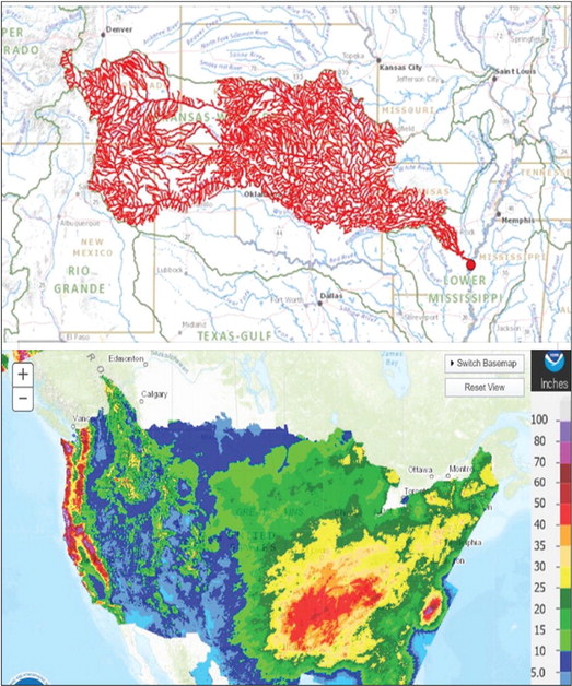
The red lines on the above map show all of the lakes, streams and rivers that ultimately flow into the Arkansas River, which has seen its banks overflow thanks to extended periods of higher-than-average rainfall and traditional northern ice melt runoff.
Photo courtesy of LRD, U.S. Army Corps of Engineers


